


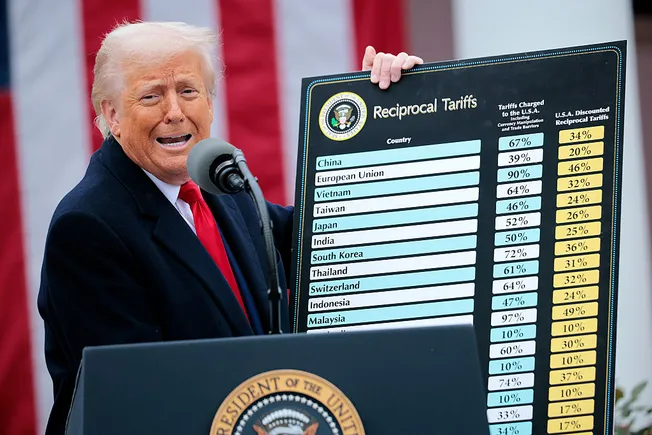


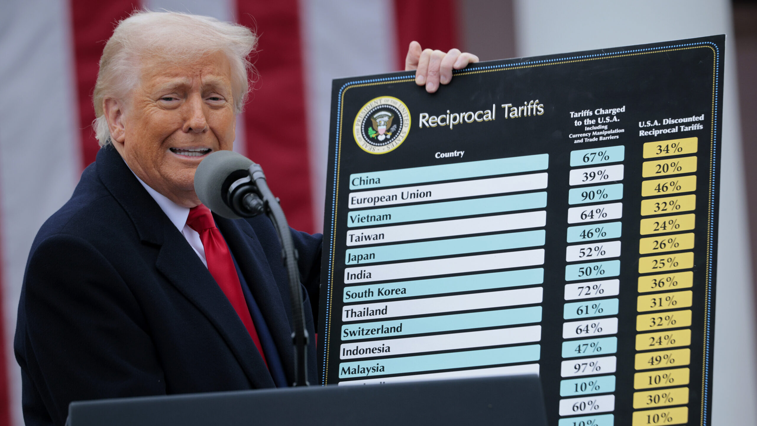


.jpg)
NGA suspends Ukraine’s access to commercial satellite imagery
However, several industry sources said that their companies have not been blocked by NRO from taking pictures over Ukraine.


Analysts at the National Geospatial-Intelligence Agency (Photo: NGA)
WASHINGTON — The National Geospatial-Intelligence Agency (NGA) has cut off Ukraine’s access to commercial satellite imagery collected by the US government, in the wake of President Donald Trump’s decision to “pause” the flow of US intelligence and military aid to Kyiv.
“In accordance with the Administration’s directive on support to Ukraine, NGA has temporarily suspended access to GEGD, which is the agency’s primary portal for accessing commercial imagery purchased by the U.S. government,” an agency spokesperson told Breaking Defense today.
The NGA shares access to “map-ready, unclassified imagery” for more than 55 foreign partner nations, as well as with the Defense Department and other US federal agencies via the Global Enhanced GEOINT Delivery (GEGD) system.
However, several industry sources said that their companies have not been blocked by NRO from taking pictures over Ukraine. Nor, these sources point out, historically has the NRO ever used its so-called “shutter control” power to block sales of commercial imagery abroad. In other words, while GEGD information will no longer flow to Ukraine, the Ukrainian government is still able to purchase information direct from commercial providers — at least for the moment.
Satellite imagery company Maxar is the prime contractor for GEGD, and a spokesperson for the company confirmed Ukraine’s suspension today in an email to Breaking Defense.
“Maxar has contracts with the U.S. government and dozens of allied and partner nations around the world to provide satellite imagery and other geospatial data. Each customer makes their own decisions on how they use and share that data.
“One of those contracts is GEGD (the Global Enhanced GEOINT Delivery program), a U.S. government program that provides access to commercial satellite imagery that has been tasked and collected by the U.S. government. The U.S. government has decided to temporarily suspend Ukrainian accounts in GEGD,” the spokesperson said.
G-EGD has been running since 2011, and ingests unclassified geospatial intelligence from a wide variety of sources for more than 400,000 users domestically and abroad — including from US and foreign commercial satellite imagery providers, through contracts with the National Reconnaissance Office’s Electro-Optical Commercial Layer program.
“GEGD is hosted by Maxar, but it ingests data from a variety of sources,” the NGA spokesperson said.
NGA is the US Intelligence Community’s “functional manager” for geospatial intelligence, responsible for gathering data from a variety of sensors, fusing that data and providing products such as maps to the US military, POTUS, US civil agencies, and allied/partner nations. NRO is responsible for the US government’s fleet of spy satellites, and also for buying commercial satellite imagery for intelligence, surveillance and reconnaissance purposes.
“We take our contractual commitments very seriously, and there is no change to other Maxar customer programs,” the Maxar spokesperson stressed.